
Envision Gallatin Land Use and Housing Strategy: How to Engage
Do you ever wonder what our future will look like? Gallatin County is in its first phase of community engagement for its Future Land Use Map (FLUM) project, which will produce a broad strokes picture of where and how we are developing in the County. The FLUM will guide the next county zoning reform, influencing the coming five, ten, twenty years of growth.
The County needs your input to steward water resources throughout the planning process. The County is currently seeking feedback on the “Land Use Profile” story map, which portrays existing conditions in the county such as fire and flood hazards, local services, public lands, and more. Influence future land use decisions by sharing your experience as a member of this community: How do you play and work here? What do you love? What challenges do you experience? Not sure what or how to comment with water in mind? We’ve got you covered with our commenting tips.
Comment by April 14th. Here’s how:
Visit the Land Use Profile Story Map to provide feedback on existing conditions. Several maps are provided, categorized by topic.
Take the Land Use and Housing Strategy Survey
Submit comments or questions by emailing Envision@gallatin.mt.gov
General tips for Public Comment:
Explain how future zoning will impact your interests and our community.
Identify what you are seeing on the ground. Are there gaps or errors in these maps?
State credentials to support your comments, such as if you have scientific background, supporting statistics, or a lived experience.
Refer to other resources such as the Gallatin County Sensitive Lands Protection Plan, the Gallatin County Growth Policy, and the Greater Yellowstone Climate Assessment.
The Gallatin Watershed Council is showing up as a voice for water. As we provide comments, we are thinking about how we are protecting watercourses from degradation, how we are maintaining areas that replenish our groundwater, centralizing growth to utilize existing infrastructure, supporting agricultural businesses, and advocating for open spaces. Get tips for your own public comment in our engagement guide below.
Engagement Guide
The following points are organized by the topics addressed in the Land Use Profile Story Maps:
Existing Land Use
Open space is critical for healthy rivers and streams, wildlife habitat, and agricultural operations. Between 2000-2021, 67,000 acres of open space were converted for housing in Gallatin County. Centralized growth around existing infrastructure and services helps keep open space open.
Inconsistent and incomplete water resource regulation creates a confusing and unequal playing field across Gallatin County. A maze of overlapping regulations in some places and none at all in others is challenging to navigate for planners, developers, and landowners. Rivers and streams work as a connected network, in tandem with their riparian areas, wetlands, and floodplains. The burden to care for our water resource is unequally distributed and gaps in regulation allow for the actions of some people to negatively impact others.
Agricultural Land and Agricultural Water Use Facilities
An intact network of canals and ditches services over 70,000 irrigated acres of irrigated farmland and is an important component of the Gallatin Watershed’s hydrology, spreading water out and recharging groundwater to support downgradient well users and late season stream flow.
Agricultural water users work together to maintain almost 1,000 miles of canals and ditches across the Gallatin Valley. Regular operations and maintenance can include the use of heavy machinery and burning. The conversion of agricultural land to development can complicate irrigation infrastructure maintenance and compromise its ability to serve our community.
Canals and ditches collect and convey stormwater and high groundwater. They divert water around our homes and roads, but can also get blocked and/or become overwhelmed and are subject to flooding.
Contiguous farmable land is critical for agricultural operations. Checkered development can fragment agricultural operations, impacting farmers’ and ranchers’ ability to safely move equipment and livestock between fields.
Thriving agricultural communities are central to preserving open space and the stewardship of water resources.
Centralized growth around urbanized areas helps maintain an intact and functioning irrigation network, promotes contiguous farmable land, and avoids conflict with agricultural operations.
Sensitive Lands, Hazards & Resources
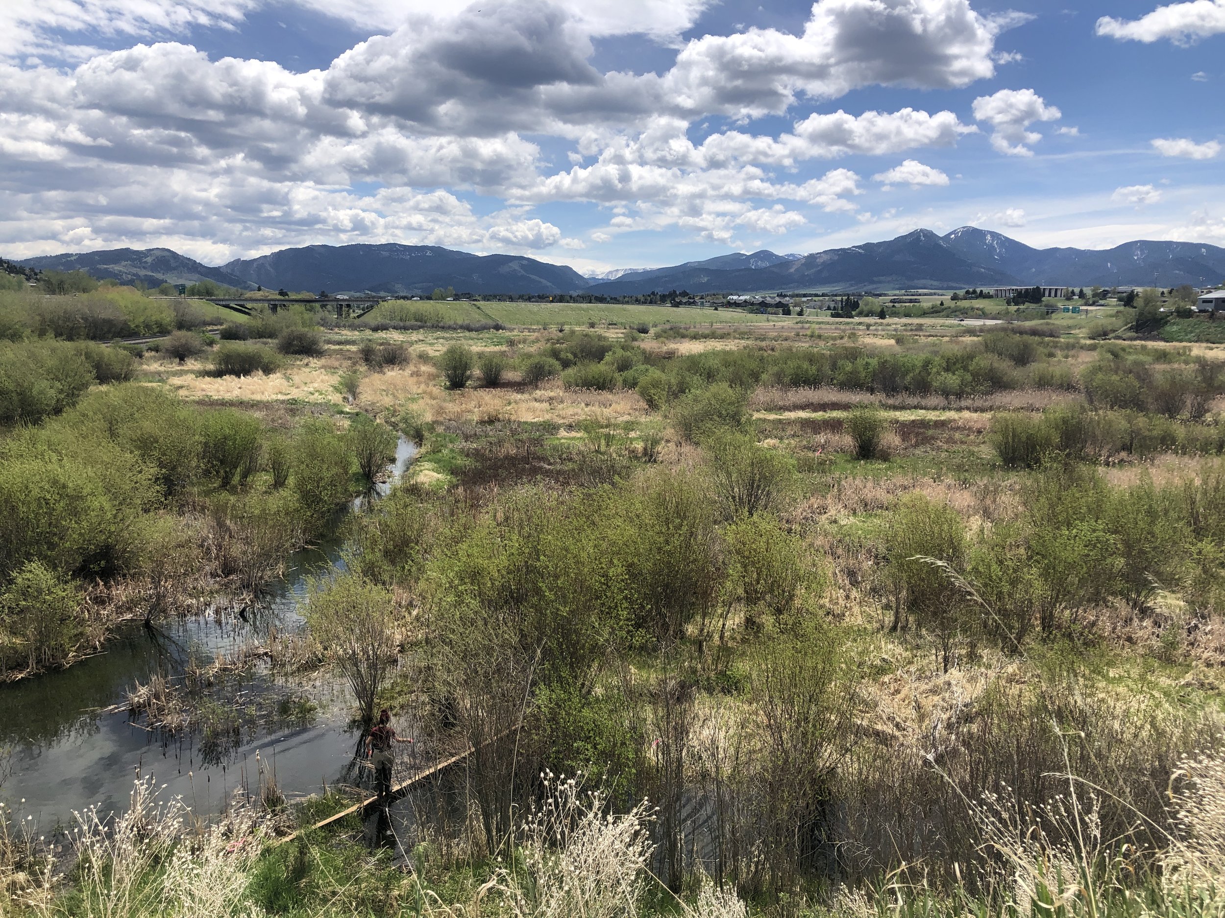
Watercourses need space to flood, erode, and support riparian vegetation. Healthy waterways are able to minimize risk to infrastructure and property, naturally slow and store water, provide fish and wildlife habitat, and treat and filter pollution to maintain clean water. To do their job well, scientific guidance recommends minimum buffers on either side of a stream to be 100 feet for small streams, 150 feet for medium streams, and 300 feet for rivers.
40% of the stream miles completely lack native riparian vegetation in the Lower Gallatin Watershed.
15 streams in the Lower Gallatin Watershed are considered impaired by the Montana Department of Environmental Quality and unable to sustain a healthy trout fishery and/or provide safe recreation. The primary cause of impairment is nonpoint source pollution.
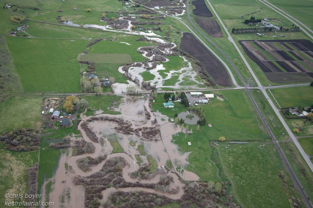
Each year, flood and erosion costs millions in damage to property and infrastructure in Gallatin County.
We share a limited supply of water. We live in headwaters watershed and our surface water has been over allocated. Most summers, water rights holders make sacrifices to keep water flowing in our streams, and “hoot owl” restrictions limit angling days.
As our climate changes it is predicted that our floods will get flashier with rain-on-snow events, and our droughts will get longer. The combined effect could strain our limited supply of water even more.
All wetlands are critical, not all wetlands are protected. Wetlands provide many services our community relies on and are unique in their ability to: provide wildlife habitat; remove pollution from stormwater and shallow groundwater; and slow and store water on the landscape. With the recent US Supreme Court decision that redefined “Waters of the US,” many of our local wetlands are no longer federally protected, specifically wetlands that are not directly adjacent to a watercourse. These “isolated wetlands” are no less important to the values and sustainability of our community.
Groundwater and surface water are very connected in the Gallatin Valley where our underground hydrology is largely characterized by an alluvial fan. When we draw water from the ground, it impacts how much water will make it into our streams and rivers. The proliferation of ponds and irrigated lawns in the County impact our water supply.
Certain areas in Gallatin Valley are ideal for recharging groundwater in the spring so that it will seep out and support instream flows in the summer. As we grow and make development decisions, it is important not to remove the ability to use this tool in the future. For example, groundwater recharge raises the water table, therefore developments in recharge zones should not include things like basements or septic systems.
Healthy forests act as a natural reservoir and are important for preventing mega-fires. 60-83% of homes in Montana are built in a wildland- urban interface (WUI) zone, which makes them vulnerable to wildfire and human-wildlife conflicts. Growth in wildfire prone areas makes managing for healthy forests more challenging.
Centralized growth around urbanized areas helps reduce the impact of development to natural resources by minimizing our footprint and providing centralized water and sewer services with a higher level of treatment and accountability.
Wildlife & Wildlife Habitat
Watercourses need space to flood, erode, and support riparian vegetation. Healthy waterways are able to minimize risk to infrastructure and property, naturally slow and store water, provide fish and wildlife habitat, and treat and filter pollution to maintain clean water. To do their job well, scientific guidance recommends minimum buffers on either side of a stream to be 100 feet for small streams, 150 feet for medium streams, and 300 feet for rivers.
Wetlands and riparian areas are the most critical habitat for wildlife in Montana’s arid climate, and almost all of our wildlife depend on riparian areas to support their lifecycle.
Local Services & Public Facilities
Septic proliferation is identified as a major contributor of nitrogen loading by the Montana Department of Environmental Quality in Hyalite Creek, Bozeman Creek, and in the East Gallatin. These creeks are all impaired for water quality and do not sufficiently support their beneficial use as a cold water fishery.
Centralized wastewater facilities provide a higher level of treatment than septic systems. Specifically, they are designed to remove more nitrogen - a leading cause of algal blooms in our rivers and streams. There is also a higher degree of accountability because centralized facilities require a permit and must monitor their discharge and achieve certain water quality standards. Incentivizing growth around existing public services is important for maintaining water quality in our groundwater and surface waters.
Many centralized water and wastewater services are struggling with capacity across the Gallatin Valley. For example, estimates suggest that at the current rate of growth, the City of Bozeman’s demand for water will exceed available supply around 2033. Guiding growth to be around existing infrastructure and services will need to be coupled with investment in infrastructure updates, innovation, and collaboration across jurisdictions to find cost effective and impactful solutions.
Stormwater management is unregulated outside of the City of Bozeman. Stormwater management mitigates the impacts of urban pollution and impervious surfaces on water quality and water supply.
Public Lands
Public lands can be multipurpose areas that are beautiful to recreate in and are managed to encourage groundwater recharge, such as unlined ponds or seasonally irrigated wetlands in neighborhood parks.
Undeveloped public lands protect water quality and are important for wildlife habitat connectivity.